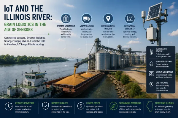
Roughly 12 million tons of food and agricultural commodities move out of Illinois annually through the LaGrange Lock and Dam alone, the farthest-downriver lock before the Illinois River joins the Mississippi near Grafton. From there, grain continues toward the Gulf of Mexico export complex centered on the New Orleans-Baton Rouge corridor, which handles roughly 60% of all U.S. grain exports. This entire system from a central Illinois farm's grain bin down to a Panamax vessel loading at a Gulf terminal increasingly runs on continuously updated sensor and logistics data rather than the periodic, lagging reports that historically governed river shipping decisions.
Illinois grain destined for export follows a structured, multi-stage path: farmers deliver corn and soybeans to country elevators at harvest, where grain gets graded, dried if needed, and stored; from there it consolidates at river-accessible terminals capable of loading barge tows; towboats then move 15-barge tows, each barge holding approximately 1,500 tons, south toward Gulf export elevators; and finally, export elevators load oceangoing Panamax or Capesize vessels bound for their ultimate destination ports. Every stage of this sequence country elevator inventory, barge loading schedules, lock transit timing, and terminal vessel loading queues represents a genuine logistics coordination point where delay at any single stage ripples through the entire downstream chain.
The USDA's Agricultural Marketing Service now maintains a public Barge Dashboard tracking weekly downbound grain tonnage locking through major Mississippi, Ohio, Arkansas, and Illinois River waterway points, updated on essentially a real-time cadence rather than the delayed, aggregated reporting that historically characterized river shipping data. A single recent weekly snapshot illustrates the granularity now available: during the week ending July 11, 2026, the Illinois River's LaGrange Lock processed 41,700 short tons of grain, including 23,200 tons of corn and 18,500 tons of soybeans figures that let grain merchandisers, farmers, and logistics planners compare Illinois River volume directly against the same week's Mississippi River lock activity, which handled dramatically higher volumes at locks like Mississippi 27 and 26. This kind of near-real-time, lock-by-lock visibility functions as a genuine IoT-adjacent data layer sitting on top of the physical barge and lock infrastructure even though the underlying locks and barges themselves aren't individually networked sensors, the continuous data aggregation and public dashboard access represents the same fundamental shift toward real-time logistics visibility that IoT technology has brought to other freight categories.
When sections of the Illinois River have closed for infrastructure rehabilitation work, the resulting shipping pattern changes have been directly measurable in freight pricing: during periods when both the Illinois River and Mid-Mississippi River routes were available for shipping, freight rates for grain originating from the Mid-Mississippi ran on average 19% higher in cash price than shipments originating on the Illinois River meaning a closure forcing Illinois shippers toward Mid-Mississippi alternatives carries a genuine, quantifiable cost premium beyond simple inconvenience. This kind of documented, real-time price differential data helps Illinois grain merchandisers make more informed shipping decisions during infrastructure disruptions, rather than relying on rough historical assumptions about relative routing costs that may not reflect current, actual market conditions during a specific closure period.
The Chicago Board of Trade's corn and soybean futures contracts specify delivery along a 403-mile section of the Illinois and Mississippi Rivers running from terminals in Chicago and Burns Harbor, Indiana south to St. Louis meaning CBOT Rulebook Chapter 7 establishes specific barge load-out procedures that automatically take effect when grain transportation is adversely affected on the Illinois River, including provisions for officially announced closures affecting delivery facilities. This regulatory structure means Illinois River conditions don't just affect physical shipping logistics they can directly affect futures contract delivery mechanics for anyone trading Chicago-listed corn and soybean contracts, giving continuous, accurate river condition monitoring genuine financial market relevance well beyond the immediate grain shipping industry itself.
During periods of low water on the broader Mississippi River system, documented operational adjustments illustrate how directly water level data translates into real shipping capacity constraints: barge operators have cut typical loads by 5,000 to 6,700 bushels per barge below the normal roughly 50,000-bushel capacity specifically to avoid grounding in a narrower, shallower channel, while reducing standard 30-to-40-barge tows down to a 25-barge maximum to account for the same reduced channel width. These aren't abstract capacity reductions they directly increase the cost and time required to move the same volume of grain downriver, with historical data during one such low-water period showing barge freight rates climbing 58% year over year to a record-high $49.88 per ton. Continuous water level and channel condition monitoring, feeding directly into these kinds of loading and tow-size decisions, represents a genuinely consequential category of sensor-driven data for Illinois grain shippers specifically, given how directly Illinois River and Mississippi River water conditions affect the state's export competitiveness.
Industry analysis presented at a 2026 FreightWeekSTL session specifically highlighted the strategic importance of the St. Louis region within this broader freight system, given how directly record corn production and strong export volumes continue driving barge transportation demand at the point where the Illinois River traffic covered throughout this article joins the larger Mississippi River system. This regional chokepoint matters for Illinois grain logistics specifically because congestion or capacity constraints at the St. Louis confluence point can create ripple effects back up the Illinois River even when the Illinois River's own infrastructure is functioning normally meaning Illinois shippers need visibility into conditions well beyond the state's own waterway segment to make genuinely informed shipping decisions.
For Illinois farmers and elevator operators, the practical value of this increasingly granular, real-time logistics data lies in better-informed shipping timing decisions a grain merchandiser with access to current lock tonnage data, freight rate differentials between the Illinois and Mississippi River routes, and water level conditions affecting barge capacity can make genuinely more informed decisions about when and how to move grain to market than one relying purely on historical seasonal patterns. Given how directly Steve Steenhoek of the Soy Transportation Coalition has noted that Illinois corn and soybean success depends substantially on inland waterway access, staying current on this real-time logistics data isn't simply a convenience it's directly relevant to the actual economics of getting an Illinois farm's crop to market competitively.
Frequently asked questions
Roughly 12 million tons of food and agricultural commodities pass through the LaGrange Lock and Dam each year, the farthest-downriver lock before the Illinois River joins the Mississippi.
Roughly 60% of all U.S. grain exports move through the New Orleans-Baton Rouge Gulf export complex, the ultimate destination for grain barged down the Illinois and Mississippi Rivers.
It tracks weekly downbound grain tonnage locking through major waterway points including the Illinois River's LaGrange Lock, providing near-real-time, lock-by-lock visibility into actual grain movement volumes.
During periods when both routes are available, Mid-Mississippi freight rates have run on average 19% higher in cash price than Illinois River shipments, a cost premium that becomes relevant when Illinois River closures force shippers to alternative routes.
CBOT corn and soybean futures contracts specify delivery along a 403-mile Illinois and Mississippi River section, meaning river closures can directly trigger specific contract delivery procedures under CBOT Rulebook Chapter 7.
Operators reduce individual barge loads by 5,000 to 6,700 bushels and cut standard tow sizes from 30-40 barges down to a 25-barge maximum to avoid grounding, directly increasing shipping costs, with freight rates once climbing 58% year over year during a documented low-water period.
Related articles

 Agriculture IoT